


A battle between a barrage of Atlantic cyclones and an intensifying ‘Bermuda’ heat dome could push Britain into the next 40C heatwave.
As the nation heaves a cool sigh of relief this week, experts warn a return to furnace temperatures could be imminent.
The Azores High, a region of high-pressure also known as the ‘Bermuda High’, is simmering off the UK south coast.
To the west, low-pressure cyclonic storms steered in on the jet stream are keeping the lid on the thermostat.
Although weather models are swinging between warm and hot, experts have warned to brace for the next heatwave.
Jim Dale, meteorologist for British Weather Services, said: “This is something we are watching, and although high pressure is building back, it is whether it builds enough over the whole of the UK to drive another heatwave.“
"We have frontal systems coming in from the west on the jet stream this week, and this is going to bring much fresher conditions.
"Next week, and during the start of July, the models are showing the potential for another spell of very hot weather, but they are back and forth on this.“
Experts have warned to brace for the next heatwave
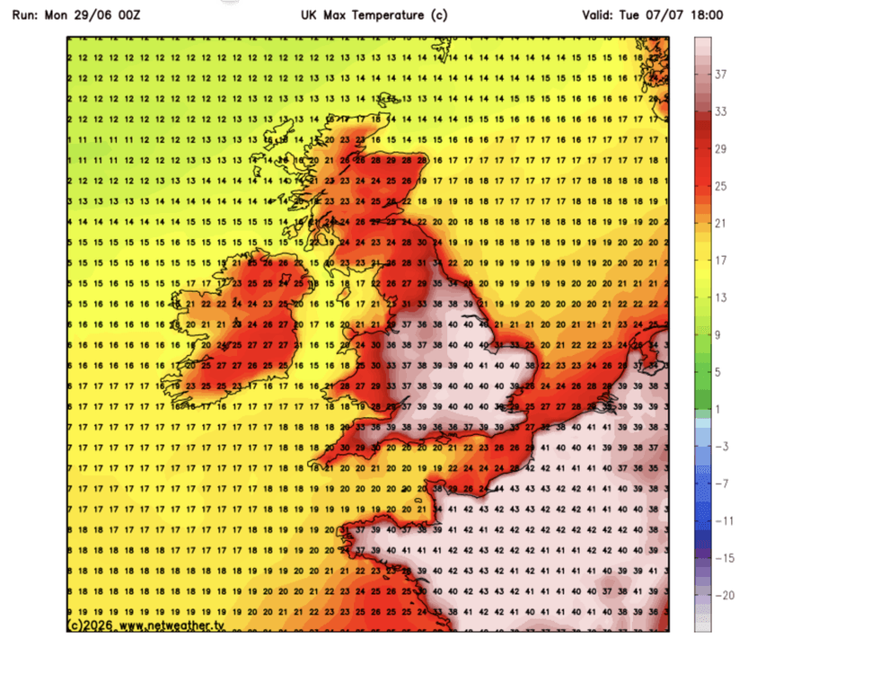
|NETWEATHER
"It could be in the longer term that we see a replay of what we have just had.”
Atmospheric instability driven by the clash of hot air left from the heatwave and fresher air from the west threatens explosive thunderstorms, he warned.
Torrential downpours are also a risk, he added, particularly across northern and western regions.
He said: “There will be quite a lot of rain in parts of the country this week, and with a lot of instability in the atmosphere, there will be a risk of thunderstorms.
LATEST DEVELOPMENTS
Britons will be making the most of a respite from a historic heatwave
|MET OFFICE
“This will bring fresher air, so temperatures will be down on last week.
"But, depending on what happens with high pressure, we could be looking at another build of temperatures."
Britons will this week be making the most of a respite from the historic heatwave which toppled records across the country.
As temperatures drop below average in parts, so will humidity, and the misery of 20C tropical nights.
Met Office meteorologist Honor Criswick said: “It is not going to be feeling so hot and humid, and there are going to be some showers pushing into the northwest at times.
“Rain could turn quite heavy overnight with some thundery downpours and Tuesday looks more unsettled compared to recent days, certainly across the northwest where we could see some heavy and thundery downpours through the course of the day.
“There is a band of showers pushing into northwest England and western parts of Wales and northwest England and these will push their way eastwards through the day.”
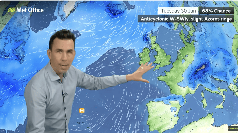
The change is thanks to the jet stream, charging the Atlantic and holding at bay the Azores high.
A battle between this high-pressure system, the jet stream, and Atlantic low pressure will hold the risk of another heatwave in the balance.
Met Office meteorologist Aidan McGivern said: “We have high pressure from the Azores trying to extend into the southwest but not quite making it.
“We have low pressure coming in across northern Scotland and Iceland bringing outbreaks of rain, and some brisk breeze at times followed by showers, so it is a changeable theme for the first of July. There is a northwest southeast gradient in the weather this week, and it will be changeable with no sign of the hot and sunny weather returning widely.”
Ms Criswick added: “It is a similar picture through the week with rain and showers at times as systems push in from the west.“But high pressure remains the dominant force, and there are signs that things will warm up again next week, but it doesn’t look as though it will be as humid.”