


A huge American storm hurtling towards Britain threatens to drag the deadly heatwave into the weekend.
Following an explosive night of tropical thunderstorms, the UK weather will come under the influence of a separate cyclonic weather system.
The giant low churning along the Atlantic jet stream will draw battle lines with a simmering heat dome bulging in from the Continent.
Depending on how the two systems lock horns, Britain could swelter in the most savage and widespread heatwave since the record-scorcher of 1976.
Met Office meteorologist Aidan McGivern said: “There is a low coming out of America, and subtle differences in terms of the track and depth of this low will make a difference in terms of how extreme the temperatures will be, especially from Tuesday onwards, how widespread the heat will be, and how long it will last.
“The jet stream is becoming wavy in a stark contrast compared to the first half of the month.
“This low is going to approach the UK, but whether it brings cloud and showery rain towards the middle of the week or whether it forces the high pressure to the south to build even further and bring higher temperatures to the rest of the UK is the source of uncertainty.”
Searing heat is forecast to peak on Wednesday or Thursday with possible highs across southern Britain of 38C.
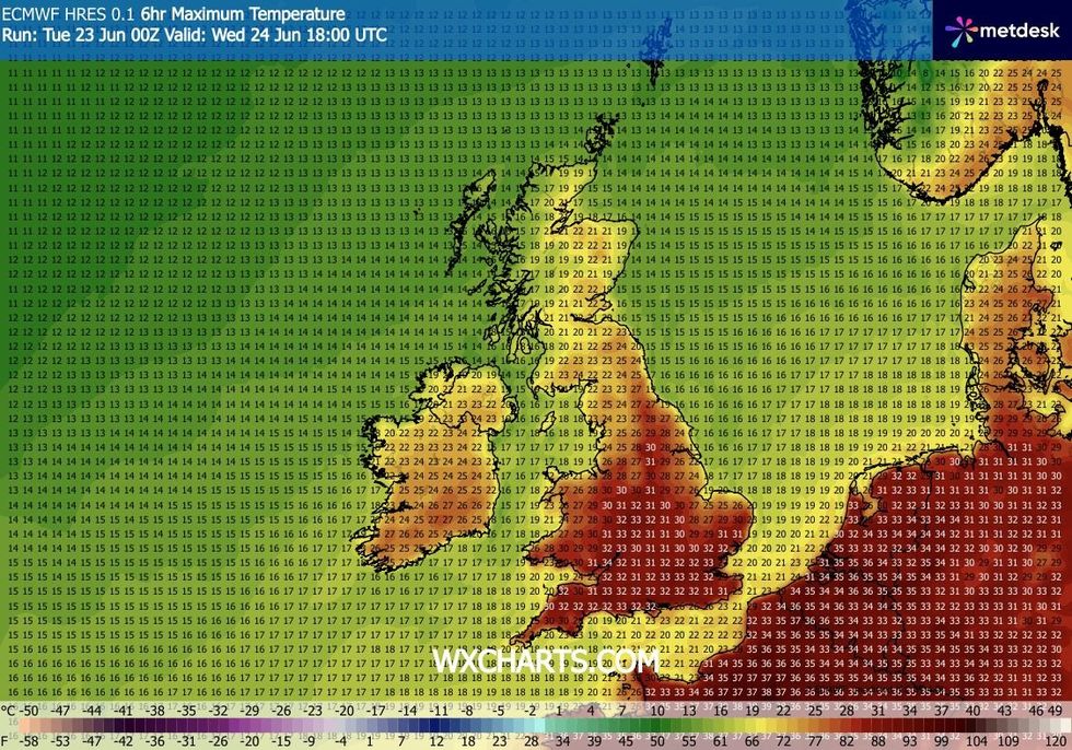
Temperatures could mirror those experienced during the 1976 heatwave
|WXCHARTS
Further thunderstorms are possible as columns of rising air hit flash point in the cloud layer.
The heatwave is being driven by a high-pressure ‘heat dome’ pushing temperatures in Europe past 40C.
High pressure is gradually nudging north into the UK, bringing with it sizzling Continental heat.
The Met Office has issued a rare heatwave warning, while the UK Health Security Agency (UKHSA) has issued a heat-health alert.
High humidity will also drive ‘tropical nights’, with overnight temperatures unlikely to drop below 20C.
Met Office Deputy Chief Forecaster Tom Crabtree said: “The forecast heatwave is developing into an impactful severe weather event, with record-breaking June temperatures and very high humidity.
“The combination of heat and humidity will be oppressive and bring impacts across society from public health and infrastructure to power and water supplies.
“As well as very high daytime temperatures, there will be consecutive nights where temperatures do not drop below 20C, which is called a Tropical Night.
“This will make it very hard for people to recover from the daytime heat, exacerbating the heat stress impacts.”
Heat this week will be made more unbearable by rising humidity and strong sunshine, hitting during the long days of the summer solstice.
Soaring UV and pollen levels will add to the recipe of misery, sparking warnings for those at risk to take extra care.
Jim Dale, creator of extreme-weather educational programme ‘The Shield’, said: “This would be exceptional were it going to happen in July or August, but it isn’t, we are only in June.
“We are at the point in the year when the days are at their longest, and UV levels are high, so people should take extra care.
“Even with this, 38C which is what we could get by the end of the week, is exceptional, and there will be an element of climate change driving this extreme heat.”