


A monsoon thunder deluge will give way to the next phase of blistering heat with thermometers to nudge 35C.
The UK Health Security Agency (UKSA) last night confirmed extreme temperatures into the middle of next week will push Britain into a heatwave.
As the heat builds, torrential downpours will drench Scotland and western Britain in up to two inches of rain.
Simmering humidity will spark electrical storms before the skies clear and the heat returns.
Met Office meteorologist Alex Burkill said: “Friday will bring some heavier rain, particularly to western Scotland, and we are expecting 30mm to 50mm in some spots, which is significant.
“We could see some thunderstorms over the southeast because of hot, humid air over us, with heavy, persistent rain and gusty winds to the northwest.
“Next week, higher-than-average pressure is most likely across the whole of the UK and much of Europe, and with that, it is looking largely dry.
“It looks like it will be significantly warmer than average, particularly across the south of the UK.”
Temperatures could reach as much as 35C
|NETWEATHER
As parts of Europe bake in possibly the hottest temperatures ever recorded, the UK will brace for the first heatwave of the season.
A UKHSA Heat Health Alert has been issued across much of England until Tuesday as the risk of dangerous temperatures builds.
The mercury will dip briefly on Saturday before ramping up on Sunday and into next week.
Mr Burkill said: “We are going to drag in hotter air on Friday, but fresher air could edge further southeast on Saturday, so it could be less hot than Friday.
“There is a heat dome across western Europe, and that is becoming more widespread over the next few days, and Paris could get its hottest ever June day.
“Sunday will be even hotter towards the south, and the heat will travel further towards the west. Whether we see a heatwave depends on Saturday, and we may not get the three-day period in many places, but we just about will in the southeast.”
LATEST DEVELOPMENTS:

Alex Burkill warns temperatures are on the up
|MET OFFICE

Alex Burkill shows which parts of the UK will be most affected by the heat
|MET OFFICE
The heat will be driven in part by a racing jet stream as it pulls in a plume of hot air from the boiling Continent, he explained.
He said: “The jet stream is running across the Atlantic and allowing an area of low pressure to develop, and this is pivotal to what happens with our weather next week.
“With low pressure to the north, we would drag in hot air and push further north, and while there is some unsettled weather, most of us are well to the west of it.
“If we see a deeper low, that would increase the southerly flow, and we could see warm air across the whole of the UK.”

Alex Burkill explains how the jet stream will affect the UK’s weather
|MET OFFICE
Hot weather will be driven by a sizzling combo of ‘home-grown’ high pressure and a tropical plume from Europe.
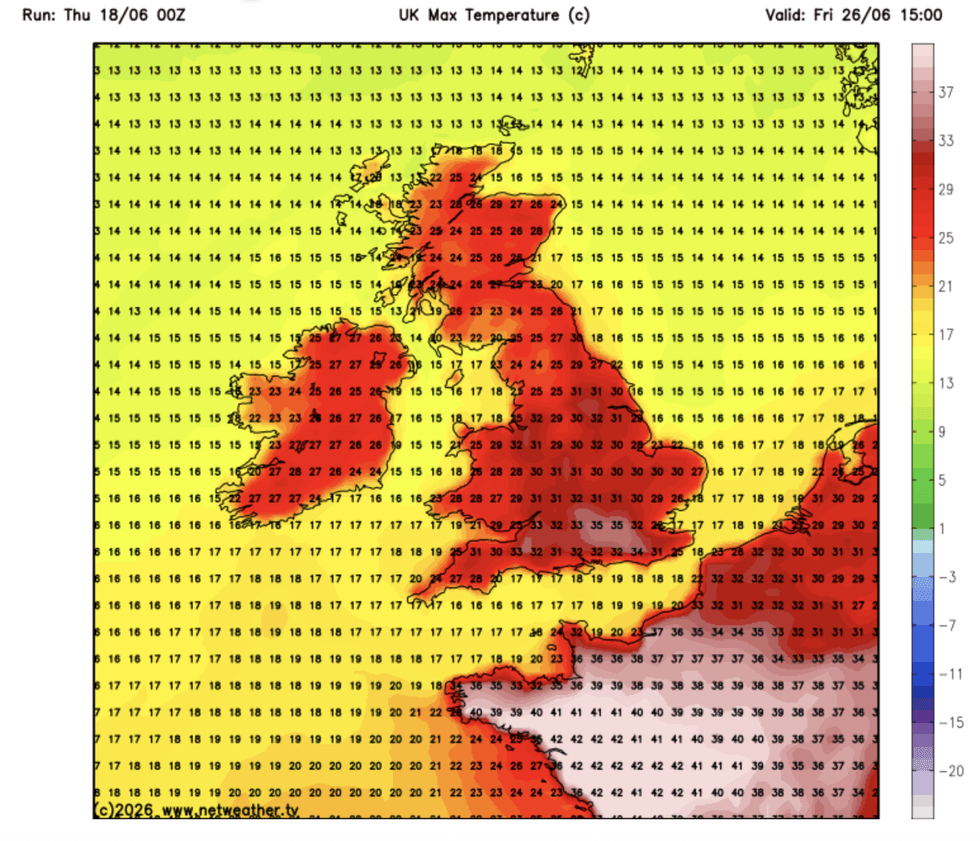
Temperatures in parts of the country could nudge 35C, according to some forecasters.
Jim Dale, meteorologist for British Weather Services and co-author of ‘Surviving Extreme Weather’, said: “Temperatures are likely to skyrocket next week, and in parts of the country we could be looking at 30C-plus, perhaps 35C.
“This is high pressure over the UK, homegrown, and hot air coming in from the Continent, which is going into its own heatwave.
“This is going to be something to watch.”