


Britain is about to boil in an unprecedented June heatwave, with temperatures over the next 48 hours nudging towards a mercury-busting 40C.
Rocketing thermometers have sparked a raft of warnings over risks to health, infrastructure, travel and power supplies.
Highs of 34C could simmer past records to 38C tomorrow as a "ballooning" European heat dome turns Britain into a pressure cooker.
Met Office meteorologist Aidan McGivern said: “An expanding balloon of heat centred over France is extending across the south of the UK.
“Intense heat is likely to develop into Tuesday, and the temperatures could be anywhere between 32C and 36C, and there is a 30 per cent chance that the England and Wales records for June will be broken on Monday and a 40 per cent chance on Tuesday.
“It then turns even hotter on Tuesday, with a maximum of 34C in the southeast with the potential for 37C.”
Southern regions will burn in the fiercest temperatures, while the north stays slightly more bearable.
Extreme temperatures will be driven by heat building from Europe as high pressure forces Britain under a magnifying glass heat dome.
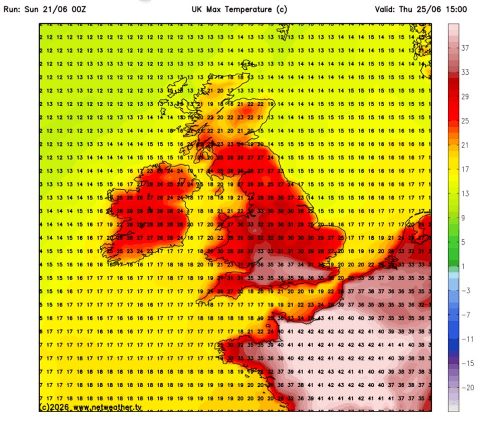
Temperatures could edge towards 40C this week, NetWeather warns
|NETWEATHER
Sinking air under the dome, originally from Iceland, will hit boiling point under the pressure.
Mr McGivern said: “The air at the surface is coming from Iceland, it’s moving over Scotland and ends up on the surface in London on Monday.
“The highest temperatures are arriving from the south, and they are going to build day by day as high pressure remains in place.
“Air is sinking significantly in the atmosphere, and as it gets caught up in high pressure, it is forced down and compressed, and that causes the air to heat up.
LATEST DEVELOPMENTS
"It is sinking air that is causing the exceptionally high temperatures.”
Hot weather will last into the middle of the week with temperatures to rocket again at the weekend, he said.
He added: “Most of the week is looking settled with high pressure close by and some of the computer models are suggesting a return to the heat at the end of the week, and that is why the Met Office has issued an extreme-heat warning.
"It is going to be very humid with the high temperatures, and there are going to be very warm nights.
“In many ways, the humidity is more important than the absolute temperatures.”
Temperatures could hit 38C over the next three days, unheard of for this early in the season.
A combination of high pressure and warm air from the continent threatens to break the June record.
Jim Dale, meteorologist and founder of extreme-weather educational programme ‘The Shield', said: “It looks like temperatures will peak around Wednesday and Thursday, and we could see a maximum of 38C around the southeast, London and the Home Counties.
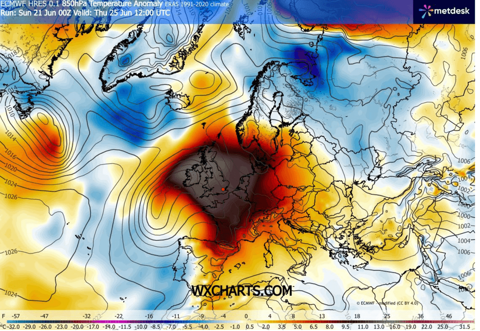
A heat dome will batter the UK this week, WXCHARTS has shown
|WXCHARTS
“This is a combination of warm air coming up from the Continent and high pressure over the UK.”
The Met Office last night expanded a rare extreme heat warning across southern and central Britain.
The alert, which was last issued when temperatures hit 40.3C in 2022, warns of adverse health effects, travel issues and power outages.
A Met Office spokesman said: “A developing hot spell through Monday and Tuesday will likely lead to widespread impacts on people and infrastructure.
“The wider population are likely to experience some adverse health effects. including sunburn or heat exhaustion (dehydration, nausea, fatigue) and other heat-related illnesses.”